
This page was made as part of a Computing project for the Computer Methods course at the University of Bristol. The page was composed using the recently updated computers in the new Esso Lab; part of the Department of Chemistry. The content on volcanoes relates to the Geology honours degree that I am reading , in the Department of Geology at Bristol university.

The Monserrat Government Information Service The volcano observatory on Montserrat giving daily updates on activity and reports from the volcano. The information is supplied by the Volcanic Explanation, a document published every morning by the Montserrat Volcano Observatory. It provides a brief rundown of activity at the site in the past twenty four hours. Some of the places mentioned are only relevant if the area is known to you. It is therefore necessary to have access to a Map of Montserrat. The map shows the location of the volcano itself as well as viable holiday options.
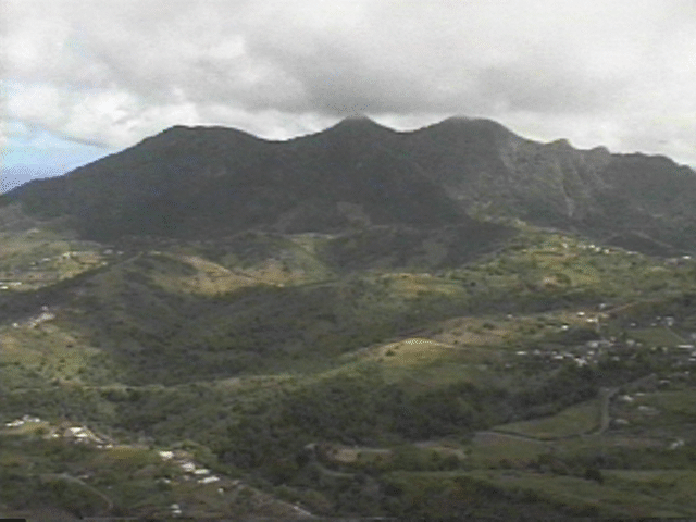
This volcano has interested many geologists as it is the first recorded eruption of the volcano, in recorded time. It has therefore provided a useful opportunity for geologists to follow the continual activity from the start of the activity itself.
The activity began on this stratovolcano on the 18th of July 1995, the first eruption itself was small and did not have a major effect on the inhabitants of the island. A small cloud of ash was produced which spread slowly around the island. However after this small eruption there was intense seismic activity which would effectively predict that there would be further activity from the volcano. This seismic activity indicated the beginning of steam and ash venting from the volcano. This in turn caused the formation of a new vent near an ancient volcanic dome (Castle Peak).
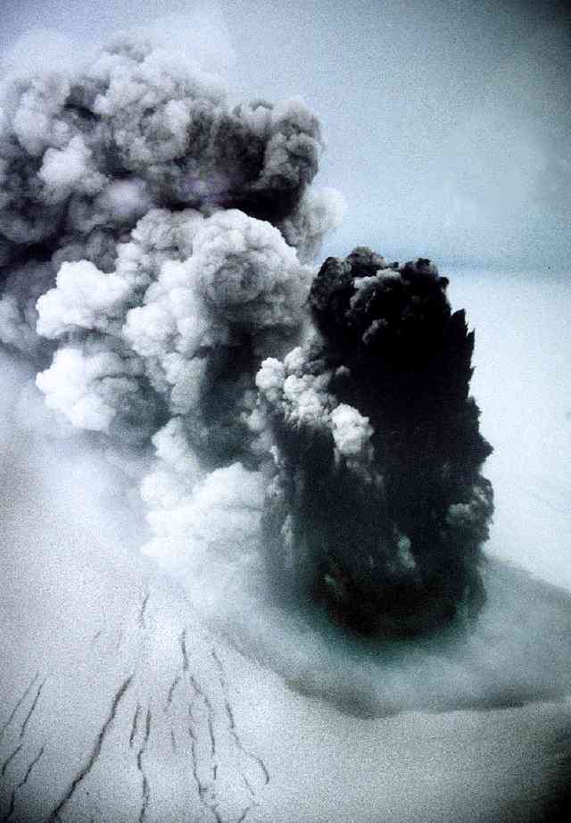
By mid to late August over six thousand people had been evacuated from the immediate vicinity of the volcano to the northern end of the island. There was an eruption on the 21st of August produced a 2,100 metre high eruption column. The subsequent ash from this eruption fell on the capital of Montserrat, Plymouth, this plunged the town into darkness. This eruption caused a series of small eruption craters to form on the Castle Peak dome.
From then until 27th of March 1996 there was little major activity from the volcano. However on this day the Montserrat Volcano Observatory reported a 2100 metre ash cloud over the volcano. This ash cloud as it was gradually forced down onto the side of the volcano still had sufficient heat to cause some dead trees to ignite. The Montserrat volcano observatory informed residents that there was no need for alarm.
The eruption changed significantly on the 3rd of April 1996. There were almost continuous earthquakes and an increase in ash emissions from the site. several explosive eruptions created several pyroclastic flows and an ash cloud of around 12000 metres. This new movement from the volcano caused the southern part of the island to be evacuated. Over the next two and a half weeks the eruption changed yet again and the eruption style became less threatening than the many eruptions on the 3rd. The eruption lessened in intensity and the most noticeable effects of the continuing situation were low intensity eruptions and moderate sized ash clouds. Although the situation was still observed with grave concern by many vulcanologists due to periods of low amplitude tremor and small explosions and rock falls. After this report most of the information I located seemed to be of minimal significance and so I move on to the next major incident at the volcano.
January 20th 1997 - February 2nd 1997 after a minor pyroclastic flow on the 20th the South East part of the dome remains unstable. The main problem with the lack of stability in the dome is the magma containing a high percentage of gas which runs just below ground level in many places. if the dome collapsed then this gas would be exposed to oxygen and hence explode. The resulting explosion could equal that of a nuclear bomb.
February 4th 1997 Ash was thrown over 2400 metres above sea level. Everyone on the island has been advised to wear dust masks.
April 6th 1997 On English television Channel four aired a programme about Montserrat giving some insight into the views shared by the islanders, the governor of the island and the work done by the MVO.
The Grimsvotn volcano presents an entirely different situation to the one presented in Montserrat. The volcano itself, in this case, is situated underneath the Vatnajokull glacier, the glacier is 400 - 600 metres thick . This presents an added risk during an eruption from meltwater. The eruption was triggered by an earthquake beneath the Bardarbunga volcano, which itself triggered several earthquakes under adjacent volcanoes. Grimsvotn was one of these. The initial earthquake caused a four kilometre long fissure to open on the north side of the volcano.
The eruption continued under the ice with few visible signs of it other than steam rising from the fissure. However on the 2nd October 1996 the steam changed colour from light to dark. This was an indication that the eruption had broken through the glacier. Along with this change in steam colour came an eruption column which rose to 5000 metres above the volcano. The fissure extended to around ten kilometres. The large volumes of meltwater produced by the eruption have nearly filled the Grimsvotn caldera. The prediction at this point in time was that there would be a Glacier burst, or jokulhlaup.
By October the 4th 1996 the eruption was continuing at a similar rate but there had been some changes. the vent was now under fifty metres of water steam clouds were rising up to 10 000 metres above the vent and various explosions throw black ash up to 300 metres into the air. From this point onwards activity at the volcano gradually decreased until on October 13th 1996 the Nordic Volcanological Institute announced that the eruption was over. Even so on the 18th of October quantities of meltwater continued to flow into the Grimsvotn caldera. Water rose to 50 metres higher than the expected level for a glacier burst and resulting Jokulhlaup.
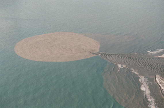
The long awaited jokulhlaup began on November 5th in the early morning. The flow of water was estimated at 6000 cubic metres per second. This powerful flow destroyed many bridges and powerlines in Iceland. The flow of the jokulhlaup is well documented and there are many pictures (University of Cambridge) available . The floodwater washed up to 100 tons of volcanic material and clay out to sea . This can be seen well on several of the pictures on this University of Iceland website. The brown discoloration of the water could be traced up to fifteen kilometres out to sea. The total estimated cost of the Jokulhlaup is over Ł6 000 000. As the total population of Iceland is only 250 000 the total repair of the island will take many years to accomplish.
Any Comments? Please mail me :rg6187@bris.ac.uk