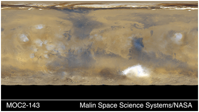
Mars Global Weather Monitoring
Twelve orbits a day provide the MOC wide angle cameras a global "snapshot" of weather patterns across the planet. Here, bluish-white water ice clouds hang above the Tharsis volcanoes (left), as well as other regions. The map is a mosaic of 24 red and blue MOC wide angle camera images taken on a single northern summer day in April 1999. The image is a simple cylindrical projection with 90°N latitude at the top, 90°S at the bottom, and 180° longitude on both the right and left sides. The equator runs across the center of the image, and the prime meridian (0° longitude) runs down the center. The high southern latitudes at the bottom of the image (from about 60°S to 90°S) are black because this region was in total winter darkness at the time the data were collected.