Late Summer Storms Over the North Polar Region

Storm clouds have been brewing over the north polar cap of Mars since the last week of June 1999. During the month of July, summer was ending; autumn began at the start of August. The wide angle cameras of the Mars Global Surveyor (MGS) Mars Orbiter Camera (MOC) have been documenting the changing weather patterns of the red planet nearly every day since the Mapping Phase of the mission began in March 1999. These images are showing many more details about Martian weather than had been previously recorded. Mars is a dynamic planet, with weather systems as complex and exciting as the Earth's.
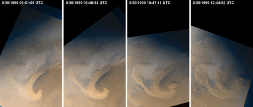
The four still-frame images (above) show the evolution of a storm system that developed over the Martian north polar region on June 30, 1999. Each picture was taken approximately 2 hours later than the previous. The north polar ice cap is the white feature at the center of each frame. Clouds that appear white consist mainly of water ice, clouds that appear orange/brown contain dust.
This particular storm system lasted well into the next day--July 1, 1999. A total of 23 red and 23 blue camera images were used to create a time-lapsed "movie" that displays the development and evolution of this storm over the two-day period. Of great interest are the "curling" of the clouds behind the largest of the storms--this indicates a flow vortex that follows the storm front that is moving toward the top/upper right of the frame--and the correlation of white water-ice clouds with orange/brown dust clouds. High surface winds must have raised dust and mixed it with water vapor in the air over the summer-time polar cap to create this effect.