| Contents | Introduction | Normal Pacific currents | Changes with El Niño | ||
|---|---|---|---|---|---|
| Measurement | Effects | Research | Prediction | Conclusions | |
| Contents | Introduction | Normal Pacific currents | Changes with El Niño | ||
|---|---|---|---|---|---|
| Measurement | Effects | Research | Prediction | Conclusions | |
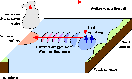
The reasons for the cell are still somewhat unclear. The trade winds are driven by coriolis force: relative to space they blow towards the equator but are deflected west by friction with the spinning earth. The upper atmosphere jet streams which form the return leg always travel east around the earth (staying still relative to space). The cell is driven by convection in the western Pacific.
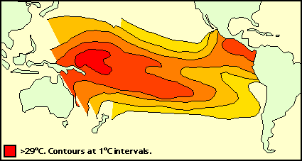
Friction of the trade winds with the ocean surface causes water to be dragged across the ocean surface from east to west along with the winds. This has effects at each end: At the eastern end cold waters are pulled up from the depths of the Peru-Chile trench, full of nutrients, thus enabling high fish populations. At the western end the waters, having warmed due to their passage beneath the equator, gather around Indonesia, causing the sea level around the Philippines to be around 60 centimetres higher and 8 degrees C warmer than that off Panama, the warmest ocean surface anywhere. The typical location of the upwelling is shown by the sea surface temperature (SST) map below, taken from satellite data for a non-el Niño year. Realtime plots of the same data are available here. The waters around Indonesia sometimes reach 31.5 degrees C. Maps of current sea levels and surface temperature measured by the TOGA-TAO bouy array is available at this site. More sea surface height data can be obtained from a form page here.
As this warm water gathers it pushes down the thermocline (the boundary between the warmer surface and deeper colder waters). This is usually about 40 metres in the East Pacific but may be 100 or 200m in the west. The shallow thermocline in the east is what allows the colder waters to be pulled up from the depths; the shallow eastern thermocline is caused by the displaced cold water from the west Pacific.
The gathering of warm water around Indonesia causes a great deal of convection in the atmosphere above it - the convection reaches 50,000 feet. As well as causing some of the highest rainfall totals in the world this actually drives the Walker cell itself. The whole cell depends on this fragile positive feedback loop: the cell causes the gathering of warm water, which in turn causes the cell.
Bjerknes explained all this by writing that "an intensifying Walker Circulation also provides for an increase of east-west temperature contrast that is the cause of the Walker Circulation in the first place." He referred to it as a chain reaction.
Next: changes that occur with El Niño
![]()